Posts

Showing posts from January, 2023

Peninsula Drainage System

Image
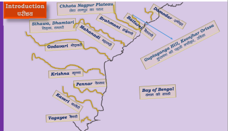
  Introduction Peninsula rivers are older than the Himalayan rivers. They are non-perennial rivers with a maximum volume of water in the rainy season. The peninsular rivers have reached mature stage and have almost reached their base level. The vertical down cutting is absent that are characterized by broad and shallow valleys. The riverbanks are characterized by the gentle slopes. he main water divide of peninsular rivers is formed by the Western Ghats extending from north to south close to the western coast. The velocity of water in the rivers and the carrying capacity of the sediments of the streams is low due to low gradient. The major rivers of the peninsula such as the Mahanadi, the Godavari, the Krishna and the Cauvery flow eastwards and drains into the Bay of Bengal. These rivers make famous deltas at their mouths. But the rivers flowing westwards such as Narmada and Tapi drains in the Arabian Sea forms estuaries in place of deltas There are rivers form superimp

Himalaya Drainage System

Image
Drainage System is an integrated system of the major stream and tributaries, which collect surface water to sea, lakes or some other body of water. Drainage Basin : The total area that drains water to a single drainage system is known as a drainage basin which are separated from a neighbouring basin by ridges and highlands hence, forming divides. Drainage Pattern: A geometric arrangement streams in a region is known as drainage pattern. Factors controlling drainage pattern : topography, slope, structural control, nature of rocks, tectonics activities, supply of water. Every stream or river forms unique pattern of drainage with their tributaries. Drainage Systems Based on the Size of the Catchment Area : Major River- 20,000 Sq km,  Medium River- 20,000-2,000 Sq km ' Minor River - 2,000 and below Sq km. Drainage Systems Based on Origin The Himalayan Rivers : The Indus, The Ganga, The Brahmaputra and their tributaries. Perennial rivers Non-Perennial rivers : Mahanadi, th

Coastal Plains and Island

Image
INTRODUCTION Total length of coastline in India is around 7516 Km. If we exclude to the length of coastline of islands, the length of coastline of mainland is 6100 Km. The average width of western coastal plain is around 64 Km. Almost all rivers here forms estuary on their mouth. The number of fagoon lakes are more over here and the ports are. also more on this coast.  The average width of the eastern coastal plain is between 120-32 Km, which has more width in the south than the north. This coastal plain has less amount of lagoon lakes the famous are Chilka and Pulicut, also has less amount of ports. The states having coastal boundary are- Gujarat, Andhra Pradesh, Tamil Nadu, Kerala, Maharashtra, Orissa, West Bengal, Karnataka and Goa. Island of India India has thousands of islands in its oo territory but only few among them has the human settlements. Around 247 islands of India has the human Rs settlement in which 43 island are in the Arabian sea called Lakshadweep Islands and 204 are

The Peninsular Region

Image
The Peninsular Uplands of India are the most prominent region for several of India’s developments. On the basis of the major relief features, the Peninsular plateau can be divided into three broad groups: (1) The Deccan Plateau  (2) The Central Highlands  (3) The Northeastern Plateau. The Peninsular Plateau is by the mountain and hill ranges varying from 460 to 1,220 metres is height. Prominent among them are the Aravalli, Vindhya and Satpura.  The Peninsula is surrounded by western ghats on the one side and by the Eastern Ghats where average elevation is about 610 metres. where it varies from 915 to 1,220 metres, rising in places to over 2,440 metres. There is a narrow coastal strip between the Western Ghats and the Arabian Sea while between Eastern Ghats and the Bay of Bengal there is a broader coastal area. The southern point of plateau is at the Nilgiri Hills where the Eastern and the Western Ghats meet. The Cardamom Hills is regarded as a continuation of the Western Ghats. The Vin

Indo-Gangatic, Brahmaputra Plain

Image
 Indo-Gangatic, Brahmaputra Plain Introduction It is also called the Great Plains India. It is formed by the fluvial process of the river Ganga and its tributaries. It is the largest physical classicistic of India. Great Plain region has largest population of India. This region has highest crop production of India hence it also called the bread bucket of India. It is one of the most fertile plain of the world. Bhabhar and Tarai Region  The Bhabhar region is spread in the parallel to the south of Himalaya from Indus to Tista rivers.. Bhabhar region is spread as a belt of 8-16 Km. Tarai region is spread parallel to the south of Bhabhar region as a beltof 20-30 Km. Bhabhar region are those region where the rivers are disappears due to the river sedimentation. Tarai region are those region where the rivers are reappears. Bhabhar region are not suitable for the agriculture practice. Khadar Region  The Khadar plains are the lowland region, formed by the new alluvial soil. Khadar region every

Himalaya

Image
Physiological Division of India On the basic of relief feature or geomorphology or topography India is physically divided in to following six parts. 1. Mountain region of India. 2. Plains of River Ganga 3. Peninsular region of India. 4. Thar Desert 5. Coastal region of India. 6. Island region of India. The Himalayan Mountains  Himalayan Mountain Range is the highest mountain range of the world. The Himalayan Range it's the third longest range of the world after Andes and Rockies. The average elevation of the Himalaya is around 6000 meters. The highest Peak of the Himalaya and the word is Everest, located in Nepal where it is also called as Sagarmatha. Himalaya it's called Chomolungma in Tibet. Second highest peak of the world is K2 or Godwin (8611mt.) Austen, which is also the highest peak of India, located in Kashmir. Third highest peak of the world and second highest peak of the India is Kanchanjangha, located in the Sikkim.  Eastern most peak of Himalaya is Namcha Barwa, loc

Geography of India (Geological Structure of India)

Image
Geological Structure is the  study the formation of bedding system of rock structures and how these structures affect tectonic movement. The Archean Era The earliest phase of tectonic movement was marked by the cooling and solidification of the upper earth’s crust surface in the Archaean era (before 2.5 billion years). This is represented by the exposure of gneisses and granites especially on the Peninsula. The term Archaean was given by J.D. Dana in 1872 to designate the geological formations which are older than the Cambrian period. The Geological structure of Archaean Era is divided into two divisions as:   1. Archaean   2. Proterozoic The Archaean rocks were structured during the very early period when there was no signs life on the earth. They are mostly igneous origin. They also consist of metamorphosed granitic and basaltic rocks together. They consists of granitic rocks, gneisses, schist, etc,. The basic structure of life was originated on this planet nearly 2500 million years.