Himalaya Drainage System
Drainage System is an integrated system of the major stream and tributaries, which collect surface water to sea, lakes or some other body of water.
Drainage Basin: The total area that drains water to a single drainage system is known as a drainage basin which are separated from a neighbouring basin by ridges and highlands hence, forming divides.
Drainage Pattern: A geometric arrangement streams in a region is known as drainage pattern.
Factors controlling drainage pattern: topography, slope, structural control, nature of rocks, tectonics activities, supply of water.
Every stream or river forms unique pattern of
drainage with their tributaries.
Drainage Systems Based on the Size of the Catchment Area: Major River- 20,000 Sq km, Medium River- 20,000-2,000 Sq km ' Minor River - 2,000 and below Sq km.

Drainage Systems Based on Origin
The Himalayan Rivers: The Indus, The Ganga, The Brahmaputra and their tributaries.
Perennial rivers
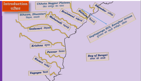
Non-Perennial rivers: Mahanadi, the Godavari, the Krishna, the Cauvery,
the Narmada and the Tapi and their tributaries.
Drainage Systems Based on the Type of Drainage- Oceanic Drainage Basins: Those rivers draining towards sea/ oceans.
Internal/Endorheic Drainage Basins: Those rivers draining into the
inland basins or lakes; such as the Sambhar.
Drainage Systems Based on Orientation to the sea- The Bay of Bengal
drainage includes rivers (East flowing rivers) that drain into Bay of Bengal.
Example- The Ganga, the Brahmaputra, etc.
Nearly 77 per cent of the drainage area of the country is drains towards
the Bay of Bengal ; about 90 per cent of the water drains into the Bay of
Bengal; the rest is drained into the Arabian Sea or forms inland drainage.
Arabian Sea drainage: Rivers (West flowing rivers) that drain into Arabian Sea.
Approx. 23 % of the drainage area of the country is oriented towards the
Arabian Sea. For instance- The Indus, the Narmada, etc,.
The Indus, the Ganga and the Brahmaputra includes
the Himalayan river systems.
The Himalayan Rivers were present even before the evolution of Himalayas which is prior to the collision of Indian Plate with the Eurasian plate. {Antecedent Drainage}.
The deep gorges of the Indus, the Satluj, the Brahmaputra etc. clearly
shows that these rivers are older than the Himalayas.
They continued to flow throughout the evolutionary phase of the
Himalayas; their banks rising steeply while the beds went lower and lower due
to vertical erosion (Vertical down cutting was significant and was occurring at
a much faster rate than the rising of Himalayas), thus cutting deep gorges.
Thus, many of the Himalayan Rivers are typical examples of antecedent
drainage.

Indus River
It originates from a glacier near Bokhar Chu in the Tibetan region at
an altitude of 4,164 m in the Kailash Mountain range near the Mansarovar
Lake.
The river flows northwest and enters in Ladakh
region in India from a place called Demchok, after entering India Indus
river flows in between Karakoram and Ladakh range but more closer to the
Ladakh range. At a place called Dungti, the river takes a sharp
southwest turn and cuts through the Ladakh range and then takes a
northwestern course and continues to flow towards the Leh region of
Ladakh between Ladhak Range and Zaskar Range. After reaching Leh
river countinues the northwestern course and reaches the town of Batalik which
is in the Kargil district.
It is joined by the Zaskar River at Leh.
Near Skardu, it is joined by
the Shyok at an elevation of about 2,700 m.
The Gilgit, Gartang, Dras, Shiger,
Hunza are the other Himalayan tributaries of the Indus.
Now the Indus river enters into the Baltistan
region through the city of sakardu and countinues to flow northwest towards the
city of Gilgit, Upon reaching the city of Gilgit the river takes a south bend
and then turns west and then fully enters the northwest frontier province of
Pakistan which is called Khyber Pakhtunkhawa.
The Kabul River empties into the Indus
River near Attock, Pakistan. It is the main river in eastern
Afghanistan and the Khyber Pakhtunkhwa province of Pakistan.
The river then takes a southwestern course and countinues
to flow across the Khyber Pakhtunkhwa province.
It then flows through the plain in western and
southern Punjab province of Pakistan, the river countinues to head towards the
Sindhu province of Pakistan.
Just above Mithankot, the Indus receives from Panjnad
(Panchnad), the accumulated waters of the five eastern tributaries—the Jhelum,
the Chenab, the Ravi, the Beas, and the Satluj.
In Sindh Province river accumulates a lot of
sediments and forms the Indus river delta before draining into the Arabian
sea near Karachi.
The blind Indus River Dolphin, a sub-species
of dolphin, is found only in the Indus River.
Ganga river
Ganga river
The Alaknanda River meets the Dhauliganga
River at Vishnuprayag, the Nandakini River at Nandprayag, the Pindar River to
form the Ganga main stream.
The Bhagirathi, considered to be the source
stream: rises at the foot of Gangotri Glacier, at Gaumukh, at an elevation
of 3892m and fanning out into the 350km wide Ganga delta, it finally empties
into the Bay of Bengal.
From Devapryag the river is called as Ganga.
Ganga debouches [emerge from a confined
space into a wide, open area] from the hills into the plain area at It is
joined by the Yamuna at Allahabad.
Near Rajmahal Hills it turns to the south-east.
At Farraka, it bifurcates
into Bhagirathi-Hugli in West Bengal and Padma-Meghna in
Bangladesh (it ceases to be known as the Ganga after Farraka).
Brahmaputra (or the Jamuna as it is known here)
joins Padma-Meghna at.
The total length of the Ganga river from its source
to its mouth (measured along the Hugli) is 2,525 km.
Haridwar, Kanpur, Soron, Kannauj, Allahabad,
Varanasi, Patna, Ghazipur, Bhagalpur, Mirzapur, Ballia, Buxar, Saidpur, and
Chunar are the important towns.
It has long been considered holy by Hindus and worshipped as the goddess Ganga in Hinduism.


Brahmaputra River
Brahmaputra River originates in the great glacier
mass north of Kailash ranges of the Himalayas (elevation 5,150 m) & south
of a lake called ‘Konggyu Tsho’.
It is only next to Amazon with a specific yield
of 85 ha m / sq km in comparison to 87 ha m /sq km of the latter.
Brahmaputra traverses a distance of 2,900 km
through four countries – Tibet (China), Bhutan, India and Bangladesh before
entering the Bay of Bengal.
The source of this river lies in the Kanglung Kang
Glacier near the Kailash range of the Himalayas located in the south-western
part of the Tibetan plateau at an elevation of 5,300 m, near Konggyu Tso Lake
Here, the river is called Tamchok Khambab Kangri.
Many snow-fed streams join the river from the passes at about 60 km southeast
of Mansarovar Lake.
It has a catchment area of 580,000 sq. km, an
average annual discharge of 19,820 cumec, an average annual sediment load of
735 million metric tonnes, and a specific flood discharge of 0.149 cumec/ sq.
km.
The catchment area of the river falls in four
countries.
Salient Features of Brahmaputra River
The river system is on the landmass enclosed on the
north by the Himalayas, on the east by the Patkai range of hills running along
the Assam-Burma border, on the south by the Assam range of hills and on the
west by the Himalayas and the ridge.
The Brahmaputra river system regions witness one of
the heaviest rainfall patterns in the world, particularly the portions in
Assam, and are prone to annual floods and riverbank erosion.
Parts of the Himalayan Mountains region of Sikkim and Arunachal Pradesh, falling in the Brahmaputra
basin, experience snow cover.
Brahmaputra river systems regions collectively are
one of the greenest parts of India, accounting for the maximum 55.48% of
the country’s forest cover.
Majuli, an island, also a district of Assam, is
known as the oldest and largest inhabited riverine island of the world,
recognised by UNESCO.
The hydroelectric potential of the Brahmaputra
river systems has been assessed at 66065 MW.
The Brahmaputra river, with a drop of elevation
4800 m, is achieved in a length of about 1700 Km in Tibet. This average slope
of about 2.82 m/Km gets reduced to about 0.1 m/Km in Assam valley.
Due to this sudden flattening of river slope, the
river becomes braided in nature in the Assam valley.
During its course in Assam valley from Kobo to
Dhubri the river is joined by about 20 important tributaries on its North bank
and 13 (thirteen) on its South bank, bringing high sediment load that results
in braiding.
All the tributaries of the valley area are rain-fed
and foam up with rain, experiencing a number of flood waves as per rainfall in
respective catchments.
The precipitation here is mainly due to the
South-West monsoon. Heavy precipitation occurs to the tune of 85% of total
annual rainfall, only during the monsoon months from May to September.
If the flood of the tributaries coincides with the
flood of Brahmaputra, it causes severe problems and devastation.
The region gets a good amount of rainfall in the months of April and May
due to thunderstorm events, which account for flooding during heavy rain in
June when the soil is already saturated and the river is in spate.


Comments