The Peninsular Region
The Peninsular Uplands of India are the most prominent region for several of India’s developments.
On the basis of the major relief features, the Peninsular plateau can be divided into three broad groups: (1) The Deccan Plateau
(2) The Central Highlands
(3) The Northeastern Plateau.
The Peninsular Plateau is by the mountain and hill ranges varying from 460 to 1,220 metres is height. Prominent among them are the Aravalli, Vindhya and Satpura.
The Peninsula is surrounded by western ghats on the one side and by the Eastern Ghats where average elevation is about 610 metres. where it varies from 915 to 1,220 metres, rising in places to over 2,440 metres.
There is a narrow coastal strip between the Western Ghats and the Arabian Sea while between Eastern Ghats and the Bay of Bengal there is a broader coastal area. The southern point of plateau is at the Nilgiri Hills where the Eastern and the Western Ghats meet. The Cardamom Hills is regarded as a continuation of the Western Ghats.

They are believed to have been formed by the remnants of the ancient Aravali mountains. Geographically, it forms the physiographic divide between the northern India from the southern India.
The western end of the Vindhyan mountain range is located in eastern Gujarat, near its border with Madhya Pradesh.
The Satpura Range extends to the eastern Gujarat near the Arabian Sea coast and runs east across Maharashtra, Madhya Pradesh and Chhattisgarh. It is triangular in shape with Ratnapuri at its and the two sides which are parallel to the Tapti and Narmada rivers. It runs parallel to the Vindhya Range, which lies to the north, and these two east-west ranges divide the Indo—Gangetic plain from the Deccan Plateau located north of River Narmada.
The Aravali Range is the oldest mountain range in India. It extends from Rajasthan in northeast to southwest direction extending nearly to 800 km. The highest peak is Guru Shikhar at Mount Abu.
The Central Highlands comprise of three main plateaus as:
a) the Malwa Plateau in the west,
b) the Deccan Plateau in the south (covering most of the Indian peninsula) and
c) the Chota Nagpur Plateau in the east.
Malwa Plateau
The most part of the region is drained by the Chambal River and its tributaries; the western part is drained by the Mahi River.
Deccan Plateau
The Deccan Plateau is a large triangular plateau, surrounded by the Vindhyas to the north and flanked by the Eastern And western Ghart.
The Deccan covers a total area of 1.9 million km?. It is mostly flat, with altitude ranging from 300 to 600 m. The region is covered by thorn scrub forest along with small pockets of deciduous broadleaf forest.
Chhota Nagpur Plateau
The Chhota Nagpur Plateau is located in eastern India, covering most of Jharkhand and adjacent parts of Orissa, Bihar and Chhattisgarh. Its total area is about 65,000 sq. km and is made up of three smaller plateaus
a) the Ranchi,
b) Hazaribagh,
c) Kodarma plateaus.
The Ranchi plateau is the largest with an average elevation of 700m. The Kathiawar peninsula in western Gujarat is bounded by the Gulf of Kutch and the Gulf of Khambat.
The Western Ghats Or Sahyadri Mountains
run along the western coast of India's Deccan Plateau and separate it from a narrow coastal plain along the Arabian Sea.
The range runs approximately 1,600 km from south of the Tapti River near the Gujarat Maharashtra border and across Maharashtra, Goa, Karnataka, Kerala and Tamil Nadu to the southern tip of the Deccan peninsula.
The average elevation is approx,. 1,000 m. Anai Mudi in the Anaimalai Hills located in Kerala is the highest points in the Western Ghats.
Eastern Ghats
The Eastern Ghats or Eastern Ghats are the discontinuous range of mountains located along India's eastern coast.
The Eastern Ghats extends from West Bengal state in the north, through Orissa and Andhra Pradesh to Tamil Nadu in the south passing some parts of Karnataka.The Deccan Plateau is located to the west of the range, between the Eastern Ghats and Western Ghats.
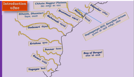
These have been eroded and drained by the four major rivers of southern India namely the Godavari, Mahanadi, Krishna, and Kaveri. The Nilgiri hills in Tamil Nadu forms the junction of the Eastern and Western Ghats.

The North-eastern Plateau
It is an extension of the main Peninsular plateau. Due to the force exerted by the north-eastward movement of the Indian plate at the time of the Himalayan evolution, a huge fault was formed between the Rajmahal hills and the Meghalaya plateau. Later, this depression got filled up by the sediments brought down by the deposition activity of the numerous rivers.
Today, the Meghalaya and Karbi Anglong plateau stand detached from the main Peninsular Block. The Meghalaya plateau is further sub-divided into three:
(i) The Garo Hills
(ii) The Khasi Hills
(3) The Jaintia Hills, named after the tribal groups inhabiting this region.
An extension of this is also seen in the Karbi Anglong hills of Assam. Like the Chotanagpur plateau, the Meghalaya plateau has its economic importance due to availability of major mineral resources like coal, iron ore etc,.
This area receives maximum rainfall from the south west monsoon. Cherrapunji exhibits a bare rocky surface devoid of any permanent vegetation cover.


Comments